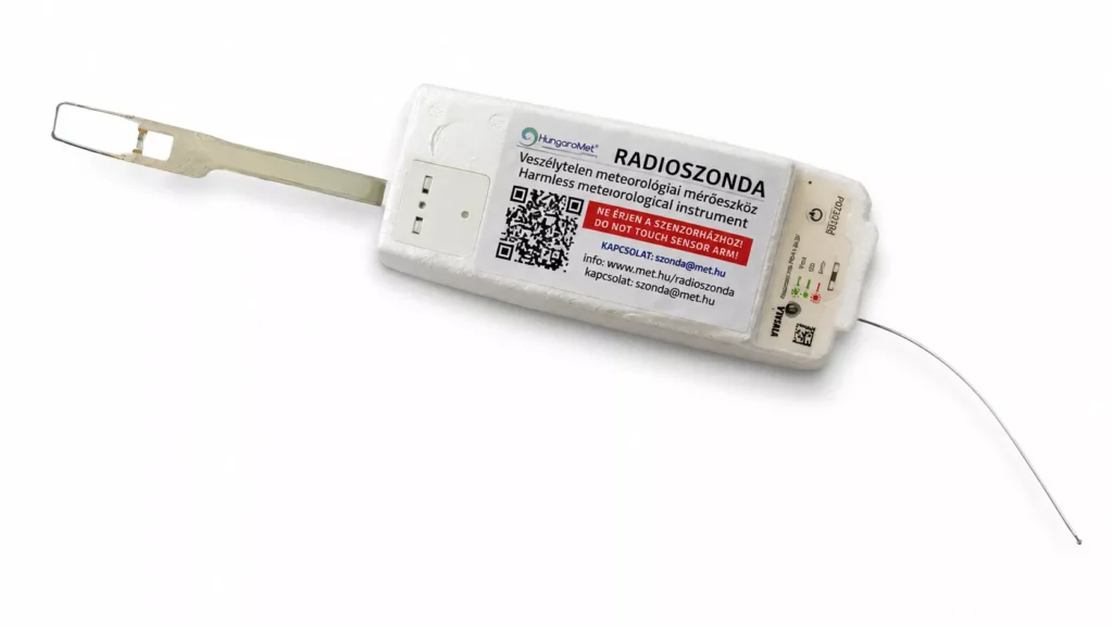
Every day, hundreds of tiny, barely visible instruments rise above our heads. These are weather radiosondes: they collect data from the lower and upper atmosphere and, a few hours later, quietly come down somewhere over fields, forests, and villages. The signals from these sondes can be received by anyone — and that’s where the exciting world of radiosonde hunting begins, attracting radio amateurs, technically minded people, and curious laypeople alike.
What are meteorological sondes used for?
A meteorological radiosonde is one of the most important tools of modern weather forecasting. The instruments are lifted by a helium- or hydrogen-filled balloon. They pass through the troposphere, where most weather phenomena take place, and rise into the stratosphere while continuously measuring temperature, air pressure, humidity, and wind conditions. These data are transmitted back to the ground in real time by radio and form the basis of weather models.
Radiosondes intended for military use are often programmed to remain silent for most of the flight and only transmit — often with encrypted data — once they reach a certain altitude or after a specified amount of time has elapsed. The data from civilian meteorological sondes are completely public; in fact, some manufacturers (e.g., Vaisala) publish detailed datasheets, and the community has documented the transmission formats in detail.
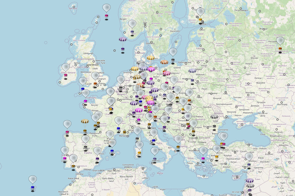
Radiosondes are typically launched twice a day from roughly 800–900 locations around the world because the data obtained this way are essential for accurate weather forecasting. In the past, they were launched by hand, but today many sites use automated launchers. In Hungary, balloons are launched twice a day from Pestszentlőrinc and Szeged around 00 and 12 UTC. In addition, in extreme weather (such as thunderstorms, freezing rain, or snowfall), extra launches may be made outside the regular schedule. These “forecast-improving” launches are typically made at 06 and 18 UTC.

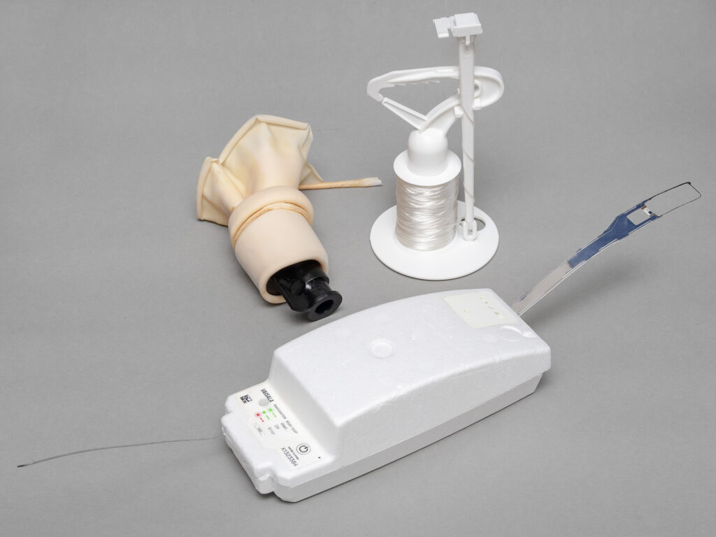
A typical radiosonde flight train consists of three main parts:
- Balloon – initially 1–2 meters in diameter; in thinning air it expands to a huge size until it finally bursts.
- Sensor unit, radio transmitter, and GPS – measure atmospheric parameters and transmit the data and position to the ground.
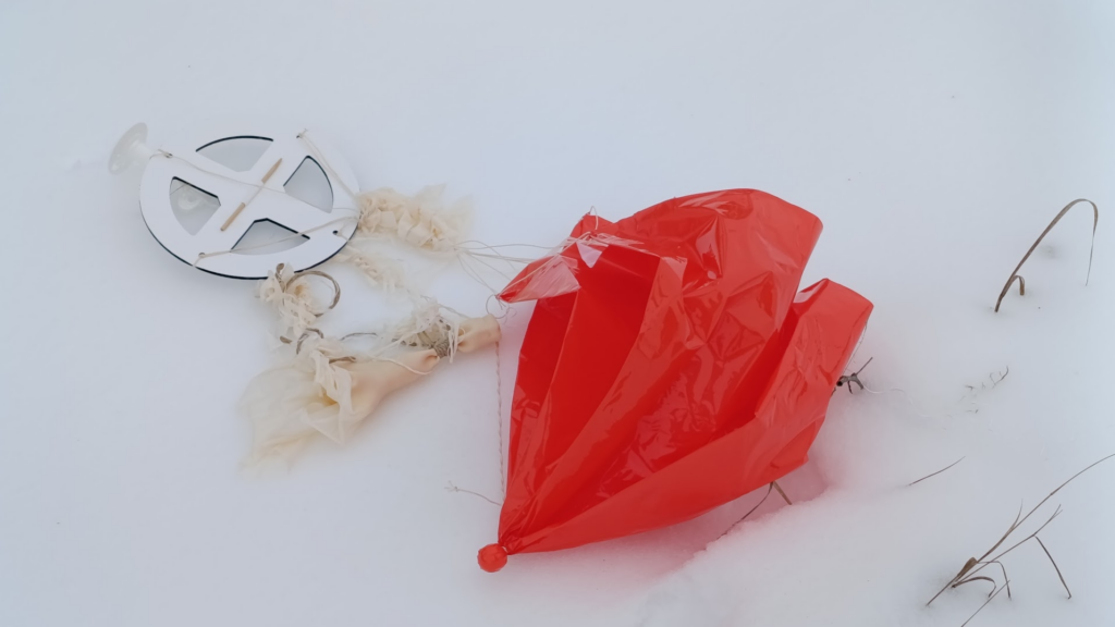
- Parachute for the return – many systems use oneto to slow the descent, mainly for safety on the ground, but details vary by type/operator.
Balloons typically fly for about 1.5–2.5 hours and, depending on balloon size and sonde type, climb at roughly 5–6 m/s to an altitude of 20–35 km (airliners cruise at around 10 km, so balloons rise two to three times higher). Near the tropopause, temperatures can drop to –60 to –70 °C, so the electronics must be kept warm: the foam housing insulates them, and most sondes rely on their own dissipated heat (some types also have dedicated heaters). The temperature and humidity sensors sit outside the insulated housing on a small sensor boom so that they measure the ambient air. The sonde hangs 30–55 m below the balloon so that the balloon’s wake does not disturb the measurements; the line is paid out from an unwinder after release.
The balloon keeps rising until it bursts in the thin air. Its horizontal motion is always caused by the wind blowing at the given altitude. In Central Europe in winter, balloons often drift strongly eastward, mainly due to the jet stream (polar jet) meandering around the entire Earth near the top of the troposphere, at the tropopause (8–12 km). Its speed can reach 400 km/h, and at our latitude it is more typical in winter and during strong weather fronts, while in summer it shifts farther north. Winds above the jet stream can also change seasonally: in winter, stronger westerly winds dominate there too, while in summer milder, at times easterly, winds can prevail. That is why, for example, sondes launched from Budapest in winter may come down in the Southern Great Plain, the Hortobágy, the Nyírség, or even Romania, while in summer they mostly land within Pest County.
The Austrians, for example, have recently been launching cheaper, smaller, and (according to the manufacturer) more environmentally friendly Meteomodem M20 sondes from Vienna. In winter they may turn up anywhere in Hungary; in summer, mainly in the northwest of the country. In Transdanubia, you can also catch those launched from Graz and sometimes Linz or Zagreb. The Slovaks sometimes launch German-made GRAW DFM-09 sondes from the Záhorie Military Technical and Testing Institute, but these only occasionally make it as far as the North Hungarian Mountains. It is rare for a sonde from Ljubljana, from Prostějov or Prague in the Czech Republic, or from Munich to reach Hungary — but there has even been a case of an Italian sonde flying across the whole country and landing near Levice in Slovakia.
When the balloon reaches its burst altitude, it pops dramatically, and the latex splits into shreds and long strips. Sometimes it disperses completely, and only a thicker piece at the filling neck remains (a small, fist-sized bundle); at other times, most of the latex (typically 350–550 g) stays in one piece and lands near the sonde. At first, the fall is very fast in the thin atmosphere (40–60 m/s); then it slows down upon reaching denser air (down to 10–20 m/s; parachuted RS41s usually land at around 5–8 m/s). In the past, parachutes were always used; today, very small and light sondes are not always fitted with one.
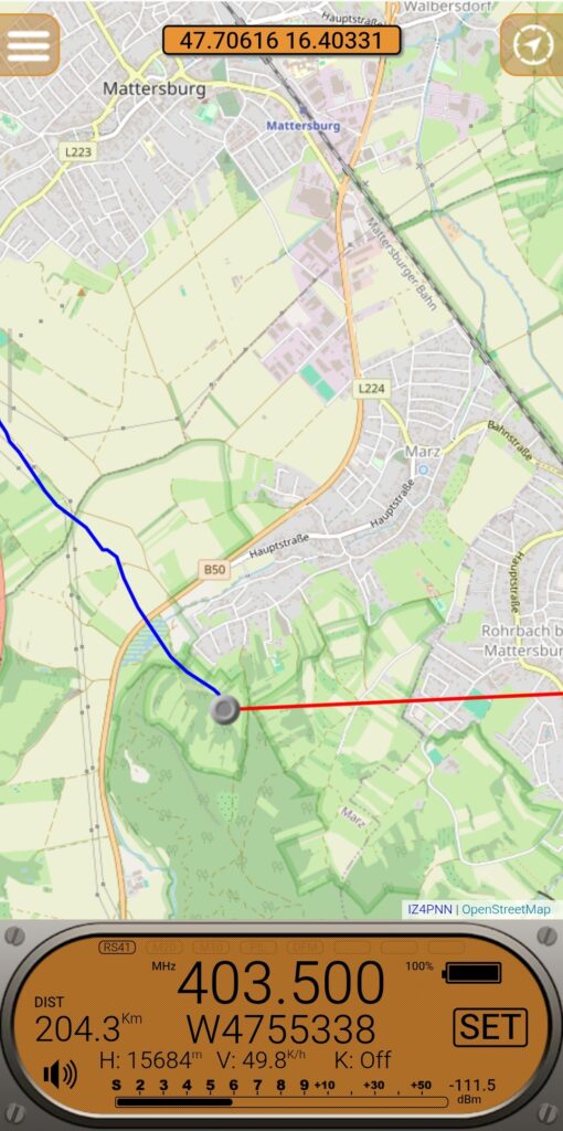
During descent, the instrument continues to transmit data, and it may even keep transmitting for hours after reaching the ground (for example, in my experience, Vaisala RS41-SG units keep transmitting for several hours after burst and Vienna M20s for 5–6 hours, but this depends greatly on type and configuration). Using the GPS data, it is sometimes possible to track the descent down to 50–100 m above ground level, after which you can find the sonde at the indicated location, much like a geocache.
UHF/VHF radio propagation is similar to that of light: for reception, the receiver must “see” the transmitter. While the sonde is high up, it can be received from very far away (up to ~350 km); when it gets close to the ground, terrain and buildings quickly “bite off” the range. The theoretical radio horizon (taking atmospheric refraction into account) is
where D is the distance in kilometers and hT and hR are the heights of the transmit and receive antennas above ground in meters. If the sonde is at 30 km altitude, in theory you could receive it from 700 km away, but due to limited antenna gain, a low signal-to-noise ratio, and the low elevation angle (terrain masking), in practice it is closer to around 350 km.
Note: To find the required transmitter height when the receiver is at ground level (hR ≈ 0 m), you simply rearrange the standard radio horizon equation. Given a distance (D) in kilometers, the required transmitter/balloon height (hT) in meters is:
For example, Vienna–Budapest is 214 km, so a sonde launched in Vienna becomes receivable in Budapest at roughly 2,700 m.
Although the meteorological service’s ground stations (with antennas near the launch site) receive the transmission from the start, in my experience, amateur stations begin to receive the signals only about 15 minutes after launch and then share them online. As the sonde descends, distant stations lose contact with it at an altitude of 200–1,500 m (depending on the terrain) because the Earth’s curvature and mountains block the path. A landed sonde’s signal can usually be received only within 0.5–1.5 km. If it has fallen among buildings or into dense vegetation, snow, or mud, the range is even shorter — often barely more than a hundred meters. Sondes float, however, so even one that has landed in water can still be received from a few hundred meters away.

Where can you track the sondes online?
One of the most convenient aspects of radiosonde hunting is that you can plan ahead: several community-driven trackers show where the sondes are in real time.
- SondeHub Tracker – live and historical tracking, map view, often with prediction.
- radiosondy.info (SQ6KXY Radiosonde Tracker Database) – “Now flying”, “Planned” and prediction views; a practical aggregator page.
- Local/regional sites and groups – often with frequency tips, reception reports, and “where it’s heading now” type info.
With these, you can quickly decide whether a given launch is worth chasing and see where it is expected to land.
Today, the international scene is broadly divided between technical developer communities (GitHub, Discord) and forums/groups that bring together field hunters. Here are the most important community hubs in the USA and Europe:
United States (USA)
- Radiosonde Central (Groups.io) – The most important mailing list in the USA. After registering you can access the archive, which contains years of experience with US sonde types (e.g., LMS6, iMet).
- Reddit – r/radiosonde – The most active English‑language community, mainly with field photos and software questions.
Europe
- Radiosondy.info – Poland‑centered but also available in English. Not just a tracker: this is the “center” of European hunting. Its forum and leaderboards are among the most influential on the continent.
- UKHAS (United Kingdom High Altitude Society) – The Wiki section is the most valuable part. Community activity happens at Groups.google.com/g/ukhas.
- Radiosonde.eu – More of an archive and technical description collection (French and English), but for identifying sonde types this is the best source in the world.
Global technical hubs (software & development)
If you’re interested in the technical background (how to decode the signal), focus on these:
- Project Horus Discord – The heart of the developer community: this is where you’ll find the people behind much of today’s tracking software (auto_rx, SondeHub). Access is via an invite link.
- GitHub – Universal Radio Hacker (URH) or the Radiosonde_auto_rx GitHub page. Under the “Discussions” or “Issues” tabs you’ll find the deep technical discussions, for example when a new sonde type (such as newer Chinese or Russian models) needs to be reverse‑engineered.

over the Sopron–Lake Neusiedl region.
How can you receive a radiosonde signal?
The barrier to entry is genuinely low: for listening, you can use even a simple UHF receiver; a basic handheld radio with a rubber-duck antenna is enough. Surprisingly, an inexpensive Chinese walkie-talkie (for example, the Quansheng UV-K5, which you can buy for roughly the price of two or three big hamburgers and which can also receive AM on the airband) is often more suitable than more expensive amateur handheld radios. The latter are more selective devices, and their input band-pass filters are tuned for 430–440 MHz, so they strongly attenuate sonde signals transmitted at 400.15–406.00 MHz. Chinese walkie-talkies, however, are wideband (400–470 MHz).
On the radio, a sonde signal sounds like a characteristic choppy, whistling, rattling tone that is usually specific to the given sonde type and easy to recognize.
Important: the frequencies in use may vary by country and launch station, so the simplest approach is to check the specific values for that day on tracker sites or in local communities.
How can you decode a radiosonde signal?
Surprisingly, this isn’t hard either. Sondes usually transmit unencrypted signals, so the data are accessible to anyone. This is a deliberate choice: the goal is data collection, not hiding. What you need:
Hardware
- RTL‑SDR receiver – an inexpensive USB software‑defined radio that typically covers the required band around 400–406 MHz.
- Antenna – a simple quarter‑wave (or GP/J‑pole) works; for direction finding a Yagi/Moxon type antenna is convenient.
- Low‑noise amplifier (LNA) – optional; it can help with long cables or a weak antenna, but with a good outdoor antenna it is often unnecessary (e.g., TQP3M9037).
Software
- Receiver software (waterfall/spectrum): for example SDR#, SDR++ – with these you can find the signal and tune it in reliably. Beginners will find a good introduction in the RTL-SDR Quick Start Guide.
- Decoding and mapping:
- radiosonde_auto_rx – automatic scanning/reception/decoding (popular on Linux, including Raspberry Pi).
- SondeMonitor – decodes multiple sonde types with map display (Windows).
I recommend SDRangel, which is an “all‑in‑one” solution: a panoramic receiver with a built‑in radiosonde decoder. It’s free and has Windows, macOS, Linux, and Android versions.
In short: the decoded signal yields a data stream containing the temperature profile, pressure, humidity, altitude, speed, and GPS position — your ‘treasure map’ in the field.
Why is it fun to “hunt” them?
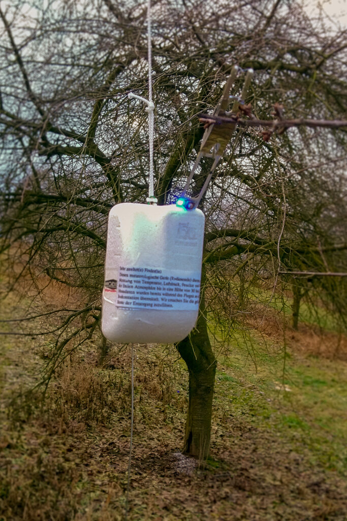
For many people, the essence of radiosonde hunting is the physical recovery of the sonde — in that sense, it really is similar to geocaching. Most radiosondes are disposable devices. In many places, there is no organized recovery program: if you find one, it is usually up to you whether you keep it as a souvenir, donate it (e.g., to a school), or dispose of it responsibly. Always read the label or tag on the sonde: if it contains return instructions, it’s polite to follow them. Until recently, HungaroMet did not ask for its sondes back (see the update at the end of this article), so anyone who finds one can take it home without worry. In the past, they had to be returned, and finders received a small reward.
Here, receiving and decoding the radio signal is primarily a means to an end: it allows you to estimate the expected landing area, after which you can head out with a map and GPS to search. Whether you finally find the device hanging from a tree at the edge of a field or in a tree belt, walk kilometers for it across a muddy plowed field, or try to row into the wind across a fishpond in a borrowed boat with a broken oar, the experience is part treasure hunt, part technical success — and you come home with a tangible keepsake.
Why look for them?
- Geocaching vibes, but with a real object. In the end, the “treasure” really is there, hanging from a tree, in a bush, or in the middle of a stubble field.
- A technical challenge you can learn quickly. With a bit of preparation (tracking → route → terrain), even the first try can be a success.
- A curiosity trophy. At first glance, a radiosonde looks as if it fell off a sci-fi film set — visitors will ask about it.
- Reusable parts. Many people salvage parts for antenna experiments, GPS projects, and DIY gadgets. Some revive the device and reprogram it, for which alternative firmware exists on GitHub. Radio amateurs turn them into beacons, fox‑hunting transmitters, garden weather stations, etc.
- You get to know your area, too. Dirt roads, tree belts, canals, fences — in real life there’s always an extra “twist” the map doesn’t show.
⚠️ Important: it is illegal to transmit with the sonde on its original frequency! The 400–406 MHz interval is allocated for meteorological stations.
You can reprogram the frequency to another band, but operating a transmitter of this power on other frequencies also requires a transmitting license (unless it complies with license-exempt short-range-device rules). If you hold an amateur radio license, you can experiment on the 70 cm band within the band plan. Otherwise, desolder the antenna and replace it with a dummy load (a 51 Ω, at least 0.6 W, low-inductance resistor, e.g., two 100 Ω 1206 SMD thick-film resistors in parallel, soldered to the board with the shortest possible leads).

Finding a sonde in practice
In the simplest case, you can search the area around the coordinates published online. You need good eyesight, and binoculars can help too (8×30 is suitable; higher magnification isn’t necessary, as it is tiring to hold steady and gives a narrow field of view). The GPS position decoded at the lowest altitude is the most accurate. If the sonde was last received and decoded near the ground, it will be nearby. If you only have data from an altitude of 1,000–1,500 m, it may have drifted anywhere from several hundred meters to a kilometer or more, especially in windy weather. It’s worth studying where the sonde came from and where it might have drifted. Tracker predictions are sometimes surprisingly good and at other times completely wrong.
Sometimes sondes keep a steady course; at other times, in the last few hundred meters, they unexpectedly change direction and “turn in.” The reason is that wind behavior changes radically in the planetary boundary layer (typically the lowest 1–2 km), most sharply in the last few hundred meters. Above this layer, the wind is close to geostrophic (blowing roughly parallel to the isobars); near the ground, surface friction from terrain, forests, and buildings slows it and causes it to back (turn counter-clockwise in the Northern Hemisphere): the Ekman spiral. This causes the characteristic “turn-in.” In addition, local flows (turbulence at a forest edge or tree line, or warm thermals rising above a motorway) can push the sonde off its previous path.
Near the ground, multipath (GPS signals reflected off terrain and objects) degrades position accuracy. As a result, the software may “think” the sonde suddenly turned or “jumped,” even though only the measurement error increased. Most experienced hunters therefore don’t look only at the last measured point: they also consider earlier data, the descent rate, and the last reliable wind vector.
If you have a radio receiver, set it to the frequency shown by the tracker (or confirmed by a local community). Many launch stations use the same frequency (or frequencies) for every launch, but this can change, so it’s worth checking the frequency before a specific hunt.
You could also search with a handheld radio and a rubber-duck antenna, watching for the strongest signal. This can be difficult within 50–100 m of the sonde because the signal seems to come from everywhere. The reason is front-end overload: the strong signal saturates the receiver. The classic remedies are an attenuator or offset tuning (tuning slightly away from the sonde’s frequency). In built-up areas, VHF/UHF signals bounce off buildings, which makes this method almost hopeless. In open terrain, however, here is a useful trick: once you have the signal, hold the radio close to your chest and turn slowly. When the signal is weakest (because your body blocks it), the transmitter is roughly behind you. By taking bearings from two (preferably three) points, you can estimate the location by triangulation. For this trick, it helps to set the radio to AM (if possible) and turn off the squelch.
A rubber‑duck antenna is not directional; by itself it receives equally from all directions. If you have a direction‑sensitive antenna (e.g., Yagi, Moxon), you can take bearings. Conventional direction-finding receivers (used by radio amateurs or ARDF practitioners) are hard to use at very close range. A Time Difference of Arrival (TDOA) direction‑finding receiver, however, can be used from 40–50 km (while the sonde is still in the air) just as well as from 10 meters.
Searching is most effective as follows:
- On online tracking sites, check the launch time and the expected landing time and place. Be careful: predictions are quite imprecise — even on a “short” 30–50 km flight the error between predicted and actual landing location can be several kilometers; on a longer journey of, say, 200 km, it can be tens of kilometers. Still, it’s worth studying the expected landing area and preparing. For example, if it’s expected to land in a swamp, wait until updated predictions show it may land elsewhere before setting off. If it’s expected to land in a large lake (e.g., Lake Balaton), either get a motorboat or forget it.
- After launch, follow the sonde online; if it is heading your way, set off. Often there are no roads to the landing location; the last few hundred meters — or even kilometers — must be walked. For planning, OpenStreetMap-based hiking maps, Google Earth, Locus, etc. are very helpful.
- Near the target, take out the radio and listen. If you can hear the signal, you’re in the right place and the sonde is still there — another hunter hasn’t taken it and it hasn’t been lost. You can try to take a bearing, or decode the signal and find it by GPS coordinates.
Field decoding is a bit different from doing it at home. Working with a laptop in the field isn’t ideal; the it may suffer (unless you have a shock‑/rain‑/dust‑resistant “field laptop”). If you have an OTG cable (and an OTG‑capable phone), you can do it with an SDR stick. SDRangel has a mobile version that works perfectly for this, but without an amplifier a better antenna helps: with a rubber‑duck antenna you may have a usable signal only within 50–100 meters, because the RTL‑SDR by itself isn’t really sensitive.
You can transfer the decoded coordinates into, say, Locus or a Garmin handheld GPS, and from that point the fun is the same as geocaching.
The most comfortable and fastest option is to have a dedicated sonde‑finding instrument. With that, searching really becomes child’s play. You start the MySondy Go app on your phone, which connects to the gadget over Bluetooth. On the phone you can set the frequency, and if reception is successful, the coordinates appear both on the gadget’s display and on the phone. The app also provides a map/satellite view. The sonde is found within a few meters of the indicated point. You can switch on the device while still approaching the landing area, and if you’re lucky and you arrive on time in a good spot, you can even watch the sonde come down.
Useful tips
You may need a pocketknife to cut the sonde off the balloon string. The string is very strong; don’t try to tear it — it won’t break, and it can cut your hand.
If the sonde gets stuck in a tree, a 7–10-meter fishing rod with a hook on the end can help. If there’s no other way, you can even attach a blade to its tip to cut the sonde free.
An ultrasonic dog repeller can also be useful, and tick-repellent spray is practically mandatory. You should also be prepared for darkness to fall during the search, or for getting stranded in the field after dark (e.g., after an accident), so always carry a light. A mobile phone flashlight is not a substitute for a headlamp!
For field searching, long pants, a long-sleeved shirt, and boots are recommended, because in scrubby terrain, vegetation will quickly scratch bare skin. In summer, a cap with a visor and sunglasses are useful; in winter, gaiters and gloves. Always have enough drinking water and a basic first-aid kit — at the very least in the car.
Dirt roads are often impassable in winter or after rain, and dusty in summer at best. If you leave paved roads, even in the best case, a sonde hunt ends with a thorough car wash. What’s more, you can’t always turn around on these roads, it’s easy to get stuck, and landowners aren’t always happy to see you driving on their land.
Sondes sometimes get caught on high-voltage power lines. Although a dry plastic string is in theory an insulator, it may be wet or dirty, and at high voltage, a flashover can occur even without direct contact. Trying to knock down or pull off a sonde caught on a power line is life-threatening! Leave such a sonde hanging — unless you want firefighters to collect what’s left of you. If necessary, report it to the grid operator.
Respect private property and restricted areas. If the sonde has landed on private property, find the owner or their representative (e.g., a guard) and explain what you are looking for and why. People are usually very cooperative, helpful, and curious. Gauge their level of science literacy and explain accordingly. Show them the recovered sonde and explain that these instruments make an important contribution to weather forecasting. They tend to like that — but the details of the day’s sounding usually don’t interest them.
If you set off for a sonde, you can announce it on a community page (e.g., radiosondy.info): you may even run into other hunters in the field. Note, however, that this is not mandatory, and there is no “official” site: posting is a courtesy, not a reservation. Whoever gets there first gets the find. Of course, avoid pointless racing — and don’t police other hunters, either. The bottom line: communicate politely and compete fairly.
Closing remarks
Weather radiosonde hunting is at once an amateur radio hobby, a data-visualization exercise, living science, and a bit of sport. The treasure-hunt element is just as present as the engineering puzzle: first you track the flight on a screen; then reality in the field (mud, fences, ditches, scrub) adds its own challenges.
Perhaps the nicest part is that the chain is transparent from end to end: you receive the signal, decode the data, plot the track, and finally find the device. With a laptop, an SDR receiver, and an antenna, you can connect directly to the ocean of data from which tomorrow’s weather forecast is made — and when you hold the sonde in your hand, it suddenly hits home that “weather” is not an app but physics happening above your head.
Sooner or later, you’ll want to know why a rising air parcel cools along the dry adiabat and, above the cloud base, along the moist adiabat — and what the measured profile’s position relative to these curves says about atmospheric stability. You’ll also learn how to interpret a Skew-T log-P diagram. But that’s another story!
Update: Return policies are changing.
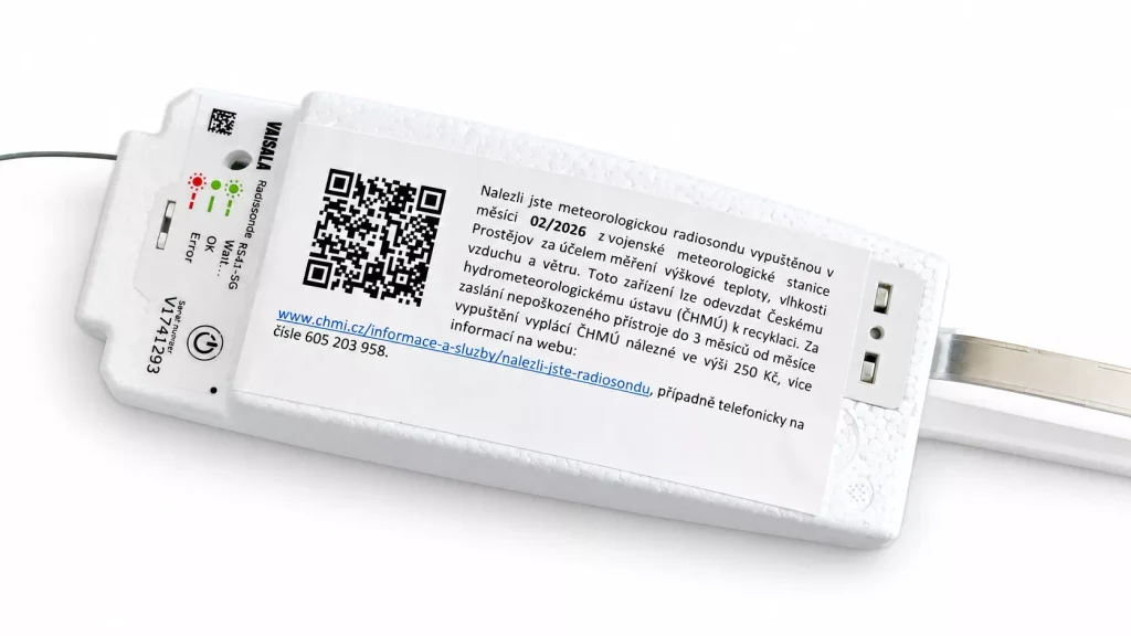
In the Czech Republic, the Czech Hydrometeorological Institute (ČHMÚ) asks for its sondes back if no more than three months have passed since the launch date printed on the finder’s tag (details: https://www.chmi.cz/informace-a-sluzby/nalezli-jste-radiosondu). If the sonde shows no obvious damage, email nalez.sondy@chmi.cz with your postal address and bank account number; ČHMÚ will send you a special transport box, and you return the sonde in it at their expense. For a working sonde, ČHMÚ pays a finder’s fee of 250 CZK within three months of receipt (for ozone sondes, which fly with a parachute, the reward is 1,000 CZK plus postage). Sondes that are damaged or were found in water or mud should be treated as electronic waste. Interestingly, the tag on the RS41-SG shown below comes from the military meteorological station at Prostějov, yet it also directs finders to ČHMÚ.
Hungary has followed suit: since summer 2026, HungaroMet has been collecting its sondes for inspection, recalibration, and reuse. Finders are asked to report every sonde, whether intact or damaged, at https://www.met.hu/radioszonda (serial number and landing coordinates); finds already logged on radiosondy.info or SondeHub do not need to be reported again, and HungaroMet forwards its reports to SondeHub automatically. Return is free: contact szonda@met.hu, and HungaroMet arranges the shipping. Only dry, intact sondes are worth returning; wet or broken ones should go to electronic waste. HungaroMet also asks for the unwinder (without the string) and the black filling valve with its white ring, as both are reusable. Unlike ČHMÚ, HungaroMet does not mention a finder’s fee.